Mangrove forests, also known as ‘inter-tidal forests’, are one of the primary features of coastal ecosystems throughout the tropical and sub-tropical regions of the world. These forests are among some of the most productive and biologically important ecosystems in the world. They support a complex aquatic food web and provide a unique habitat for a variety of animals. The waters surrounding the mangroves inhabit rich sources of fish and shellfish. The aquatic faunas of mangroves are uniquely adapted to survive under wide ranges of salinities. Besides, they are also well adapted to tidal amplitudes, temperatures, silty turbid water and hypoxic waterlogged conditions. The rich fish diversity in mangrove systems derives from diversified habitats such as mudflats and different adjoining water bodies such as rivers, estuaries, bays, intertidal creeks, channels and backwaters. Mangrove areas also act as important breeding and nursery habitats for many species of fishes and invertebrates such as oysters, shrimp, and crabs due to the high density of organic matter deposition in a relatively small area.
The mangrove forest of Bangladesh is divided into 3 zones: Sundarbans with an area of 577,040 ha, Chakaria Sundarbans in Cox’s Bazar consisting of 8540 ha, and planted coastal mangrove forests. The planted area currently covers about 100,000 ha which has been introduced in the coastal belt of Cox’s Bazar, Chittagong, Barisal, Patuakhali and off-shore islands. The plantation of mangroves is being still carried out.
A. Sundarbans mangrove wetland
Sundarbans, the single largest continuous mangrove forest in the world, lies on the delta of the Ganges and Brahmaputra rivers on the Bay of Bengal. It is formed about 7000 years ago by the deposition of sediments from the foothills of the Himalayas through the Ganges river system. This deltaic mangrove forest extends across coastal India and Bangladesh, over the northern part of the Bay of Bengal. The Sundarbans mangrove forest is located in the southwest of Bangladesh and the southeastern portion of the State of West Bengal in India with a total area of about 10,000 km2. About 62% of the Sundarbans forest is in Bangladesh and the rest is in the Indian region. It has been recognized as an internationally important Ramsar Wetland Site and declared as a World Heritage Site. In Bangladesh, the Sundarbans are located in the south-west of the country (districts of Bagherhat, Khulna and Satkhira) between the river Baleswar in the East and the Harinbanga in the West, adjoining to the Bay of Bengal. It occupies the area between latitude 21° 27′ & 22° 30′ North and longitude 89° 02′ & 90° 00′ East. It has an area of about 6017 square kilometers which is 4.13% of the country and 38.12% of the state forest land. The government has divided the Bangladesh Sundarbans into four administrative ranges which are Satkhira, Khulna, Chandpai, and Sarankhola (Habib et al, 2017).
The drainage system of Sundarbans has three sub-systems to the east, center and west, which form the estuaries of Bangra, Kunga and Raimangal. The whole area is dissected by large tidal rivers, notably the Baleswar, Shibsha, Passur, Shela, Kobadak-Sibsha, Kobadak, Arpangasia and Raimangal with innumerable small channels and creeks. The maximum elevation within the Sundarbans is only 10 m above the mean sea level. Due to the existence of numerous cross-connecting channels linking catchment areas and estuaries, the pattern of river salinity is very complex. The south and western parts of this forest have higher saline conditions whereas the northern and eastern part has low saline intensity in river and canal waters. The rise and fall of salinity in all of the rivers does not take place simultaneously. The hydrology of the Sundarbans is regulated mainly by high local rainfall during the monsoon and tidal inundation. The Sundarbans mangrove forests and other parts of the coastal area support a wide range of biodiversity viz., mammals, birds, fishes, amphibians, reptiles, crustaceans, etc.
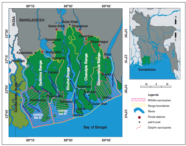
Figure 1: Physiography of the Sundarbans mangrove forest in Bangladesh (Habib et al, 2017).
The Sundarbans, Bangladesh was declared a Ramsar Site (i.e. wetland of international importance) in 1992. The water area of the Sundarbans is about 2,000 km2, which is about 33% of the total Bangladesh. The government of Bangladesh has recently updated the Ramsar Information Sheet on the Sundarbans Ramsar site enlarging its area from 596,000 to 6,01,700 hectares, and now to be called “Sundarbans Reserved Forest”. The immense tidal mangrove forests of Bangladesh’s Sundarbans Forest Reserve are in reality a mosaic of islands of different shapes and sizes, perennially washed by brackish water shrilling in and around the endless and mind-boggling labyrinths of water channels. The site supports exceptional biodiversity in its terrestrial, aquatic and marine habitats; ranging from micro to macro flora and fauna. For this reason, the UNESCO has declared the Sundarbans as a World Heritage Site in 1997.
The biodiversity of Sundarbans is noticeably rich in terms of plant and animal diversity. The Sundarbans represent a complex estuarine ecosystem dominated by dense forest cover and may be classified as a tropical moist ecosystem. A total of 528 species of vascular plants belonging to 356 genera and 111 families are found in the Sundarbans Mangrove of which 24 are true mangroves and 70 were mangrove associates. Phytoplankton, also known as microalgae communities of Sundarbans consist of a total of 111 species including nano and picoplankton. On the other hand, a total of 28 species of seaweeds have been recorded.
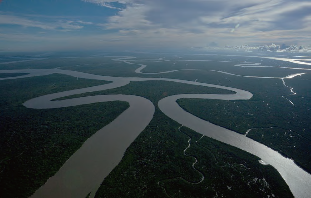
Figure 2: An aerial photo of the different rivers and canals of the Sundarbans mangrove forest, Bangladesh (Photo credit: Jonas Bendiksen; Habib et al, 2017).
Sundarbans is a unique ecosystem for the survival of the faunal community. Animals have to struggle for life in the Sundarbans due to the forest’s adverse and hostile environment. Almost all species are adaptive to tolerate high salinity and brackish water for their life cycle. All resident species of aquatic mammals, reptiles and amphibians are powerful swimmers and habituated to meeting food requirements partially from aquatic sources. In Sundarbans, a total of 447 species of vertebrate wildlife are reported to occur, of which 10 are amphibians, 57 reptiles, 339 birds and 41 mammals. Some aquatic mammals in this forest are Irrawaddy dolphins, Indo-Pacific humpback dolphins and finless porpoises.
Sundarbans is a transition between freshwater of the Ganges and saline water of the Bay of Bengal, resulting in an assemblage of unique diversified aquatic biodiversity. The water area of Sundarbans is about 2,000 km2, which is about 33% of the total forest. It is one of the most biologically productive of all natural ecosystems in Bangladesh, with great economic importance. The main aquatic resources of the Sundarbans such as white fish, prawn & shrimp, cartilaginous fish, reptiles, crabs, mollusks, dolphins, post-larvae of prawn and shrimp, dry fishery etc. Benthic invertebrates also act as a very good source of food for many bottom-feeding fin and shell fishes that enter into the mangroves during high tide for breeding. Sundarbans are inhabited by a variety of benthic invertebrates viz. brachyuran, polychaetes, crabs, gastropods, sipunculids, bivalves etc. The composition of these communities and their importance varies enormously from one habitat to another depending upon the sediment characteristics of Sundarbans. Invertebrates often show marked zonation patterns and colonize a variety of specific micro-environments.
A study on the aquatic biodiversity of Sundarbans by Sher-e-Bangla Agricultural University with the technical support of the Korea Institute of Ocean Science and Technology (KIOST) and Bangladesh Forest Department (BFD) funded by Yeosu Korea Foundation estimated that 271 species of fishes, 65 species of aquatic and semi-aquatic arthropods including shrimps (30 spp), crabs (25 spp), and lobsters (2 spp), 50 species of molluscs, 7 species of amphibians, 24 species of reptiles, 2 species of cnidarians, 44 species of zooplankton, 72 species of aquatic birds and 4 species of aquatic mammals are available in the rivers and canals of Sundarbans, and its adjacent sea area. Based on this study, an illustration book on aquatic animal and plant species of the Sundarbans entitled ‘Aquatic Biodiversity of Sundarbans, Bangladesh’ (Habib et al, 2017) was published in 2017. The book was well designed to help understand the marine and brackish water biodiversity of the Sundarbans incorporating photographs, taxonomy, morphological characteristics, global IUCN red list status, and local name for each species.
[Read Book] To know about aquatic faunal & Floral biodiversity of Sundarbans, you may read the book Aquatic Biodiversity of Sundarbans, Bangladesh.
B. Chakaria Sundarbans
Chakaria Sundarbans is a deltaic mangrove forest of the Matamuhuri River at Chakaria in Cox’s Bazar district. The initial area of the Chakaria Sundarbans was about 18,200 ha. Subsequently, 7,490 ha of land was declared as Reserved Forest and the rest as Protected Forest. This forest has been almost completely denuded in recent years. The natural treasure trove now exists only on a few hundred acres out of its original size (45,000 acres) spanning across Purbo Borobeula, Paschim Borobeula, Rampura, Charandwip, Bodorkhali, and Moheshkhali. The vast tracts of the forest have been wiped out, mostly in three decades, along with its flora and fauna. The factors responsible for the destruction of this mangrove forest are shrimp farming, salt production, high grazing pressures, fishing, fuel wood production and human settlement. The forest once acted as a shield against natural catastrophes and served as a source of livelihood for coastal people. It also used to be home to the Bengal tiger, crocodile, monitor lizard, deer, langur, wildcat, reticulated python, and a host of birds.
Chakaria Sundarbans mangrove forest, the oldest mangrove forest of the Indian subcontinent, is now only a space for producing large amounts of shrimp and salt rather than wood, non-wood or natural products. Though such production is contributing greatly to the national economy of Bangladesh, but enormously disturbs the biodiversity, and depletes the forest products. So, this mangrove forest of Bangladesh needs to be protected with a strong emphasis on the prevention and conservation of mangrove biodiversity through strict controls of shrimp farming and grazing (Dutta and Hossain 2020).
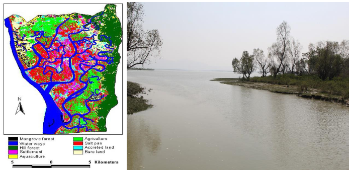
Figure 3: Landsat image (2012) showing the land use patterns and a forest patch (right)of Chakaria Sundarbans in south-east Bangladesh (Dutta and Hossain 2020)
C. Planted mangroves in the coastal area
The initiative of afforestation and reforestation of mangroves in the coastal area of Bangladesh started in 1965. The aim of the coastal afforestation in the mudflat or intertidal zones is to accelerate the deposit process and help the accreted lands to be stabilized (Mahmood et al. 2020). Bangladesh Forest Department (BFD) is conducting the afforestation and reforestation program under the Ministry of Environment, Forest and Climate Change. BFD is responsible for the maintenance and management of the plantation initiative. The toposheet map of 1950 suggests the status of the coast is far more different compared to the present status. The recent field observation, secondary literature, and satellite imagery-based observation claim that there have been increased patches of mangrove and coastal lands have also increased (Mahmood et al. 2023).
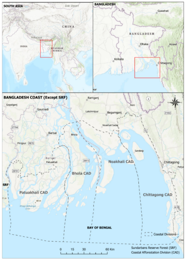
Figure 4: Coast of Bangladesh except for Sundarbans Reserve Forest. The grey dashed lines represent four Coastal Afforestation Divisions (CAD) of the country under the jurisdiction of the Bangladesh Forest Department (BFD).
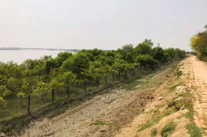
Figure 5: Mangrove trees planted between the sea and an embankment (Photo: https://news.mongabay.com/ published on 03 June, 2022).
References:
Dutta S and Hossain MK (2020) Bringing back the Chakaria Sundarbans mangrove forest of South-east Bangladesh through sustainable management approach. Asian Journal of Forestry. 4 (2): 65-76. https://doi.org/10.13057/asianjfor/r040204
Habib KA, CG Kim, Oh J, Neogi AK and Lee YH (2017) Aquatic Biodiversity of Sundarbans, Bangladesh (2nd edition). Korea Institute of Ocean Science and Technology (KIOST). 394 pp.
Mahmood R, Ahmed N, Zhang L, Li G (2020) Coastal vulnerability assessment of Meghna estuary of Bangladesh using integrated geospatial techniques. International Journal of Disaster Risk Reduction, 42:101374. https://doi.org/10.1016/j.ijdrr.2019.101374
Mahmood R, Zhang L and Li G (2023) Assessing effectiveness of nature-based solution with big earth data: 60 years mangrove plantation program in Bangladesh coast. Ecological Processes, 12, 11. https://doi.org/10.1186/s13717-023-00419-y